Environmental Risk Consulting Service
We promote environmental projects based on accurate understanding of nature and environmental conditions. When conducting a project, it is necessary to protect and conserve the environment as well as ensuring economic efficiency and safety. In addition, advanced technology and a great deal of information are required for prediction and evaluation of the environmental impacts of construction projects or infrastructure developments. To carry out a successful project, we are engaged from planning, implementation, completion to follow up surveys, and we conduct in situ investigations and rigorous simulations, making the best use of abundant information, using highly accurate predictions and evaluation.
| Ecosystem Risk | Rare wildlife survey, alien species extermination survey and planning, biotope planning and management, fishing ground environment restoration technology development, resource management type fishing ground study, forest conservation planning |
|---|---|
| Natural Environment Risk | Land environment assessment, marine environment assessment, project evaluation, environmental conservation and planning, habitat conservation planning, natural park-related surveys, eutrophication countermeasures, water purification planning, bottom sediment improvement planning |
| Living Environment Risk | Water quality/bottom sediment survey, atmospheric and other chemical substance survey, noise/vibration/traffic volume survey, support for introduction of renewable energy |
| Equipment Measurement | Wave/tidal current observation, riverbed scouring measurement, columnar sediment sampling system (VCS: vibration core sampler) |
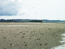
| ■Ecosystem research in Tidal Flat Zones With the increase of restoration projects in tidal flats, examination of their effects and management are made to determine progress. For adaptive management, we conduct a series of ecosystem surveys in tidal flats, from in situ investigations, evaluations/examinations to monitoring. Also, evaluations and examinations are conducted from an ecological perspective using Habitat Evaluation Procedures (HEP). |
 |
|
|
|
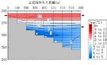
| ■Coastal Management Master Plan Based on the New Coast Act In conducting multi-ministerial/governmental coastal management, it is imperative to confirm the factors governing coastal formation by understanding and analyzing sedimentation (stratification order, history of stratification) data specific to respective coasts. A coastal management plan is essential not only for coastal erosion problems, but also for maintenance of existing facilities. |
 |
|
|
|
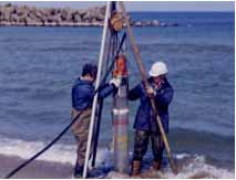
| ■Numerical Calculations It is mandatory to conduct predictive evaluations by numerical calculations to examine resolutions dealing with problems caused during development and construction processes and to validate the effects of existing facilities. We conduct predictive evaluations on water-quality related parameters from rivers upstream of reservoirs to oceans, marine physical phenomena, including currents and waves, and associated topographical changes. |
 |
|
|
|
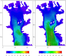
| ■Numerical Simulations of Reservoirs In reservoirs, there are diverse problems, such as discharge of cold water, long-term turbidity and nutrient depletion. We use various numerical simulation models to deal with such problems. We provide examination services for dam lakes using a one-dimensional model for general study and a two-dimensional model for detailed examination. |
 |
|
|
|
| ■Environmental Remediation Consulting Diverse environmental remediation technologies have been developed in recent years. However, beneficial effects from these will not result if they are not correctly applied, qualitatively and quantitively. We conduct investigations on the characteristics of targeted areas and propose the most appropriate remediation method based on the best technological combination of existing and developing technologies. |
 |
|
|
|
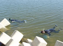
| ■Coastal Eco-Monitoring Surveys Commonly, the belt transect method has been used for intertidal biological research. However, we conduct coastal ecomonitoring surveys by focusing on targeted organisms, observing species spatial distributions and using GPS mapping, a simple, mid-to long-term monitoring method we have developed. |
 |
|
|
|
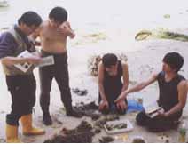
| ■Riparian zone census In Japan, the Basic Survey Manual for Riparian Bio-Census was revised in 2006. We can conduct all types of basic surveys described in the manual and provide consistent services from preliminary surveys to field surveys and data inputting to data system management. We also provide technical support and field surveys for the Riparian Bio-Census for residents. |
 |
|
|
|
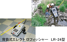
| ■Fish and aquatic life surveys The revised Basic Survey Manual for Riparian Bio-Census allows for use of electric shockers for fish and aquatic life surveys. This method has recently enjoyed growing popularity as a reliable method among quantitative survey methods because it is easy to use and does not rely on surveyor’s technical skills. An electric shocker sends short electric waves into the water allowing stunned fish to be captured with a scoop net, and immediately released after measurement. Our survey history has proved there is little harm to the fish. |
 |
|
|
|
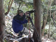
| ■Raptors Surveys In considering natural environments in local areas, the existence of raptors on the highest level of the food chain are attracting more attention. To consider conservation of their habitats and breeding grounds, our well-experienced surveyors conduct surveys and compile reports that give a comprehensive picture of environmental conditions. |
 |
|
|
|
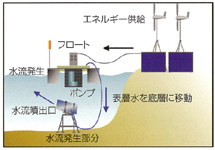
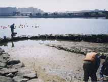
| ■Demonstration Projects for Water Environment Improvement Using Ecosystem
Based Solutions We conduct demonstration projects for water environment improvement making use of nature’s purification capacities. We construct artificial tidal flat lands in seaside parks adjacent to cities, and install rubble masonries and floating rafts. The efficacy of the facilities is continuously examined through monitoring of biota restoration and measuring of nitrogen and phosphorus concentrations. |
 |
|
|
|